


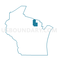
ROSS - T 1 Voting District, Forest County, Wisconsin
About
Outline

Summary
| Unique Area Identifier | 693814 |
| Name | ROSS - T 1 Voting District |
| County | Forest County |
| State | Wisconsin |
| Area (square miles) | 38.60 |
| Land Area (square miles) | 38.51 |
| Water Area (square miles) | 0.10 |
| % of Land Area | 99.75 |
| % of Water Area | 0.25 |
| Latitude of the Internal Point | 45.71189690 |
| Longtitude of the Internal Point | -88.72508670 |
Maps


Graphs
Select a template below for downloading or customizing gragh for ROSS - T 1 Voting District, Forest County, Wisconsin


Neighbors
Neighoring Voting District (by Name) Neighboring Voting District on the Map
- ARGONNE - T 1 Voting District, Forest County, WI
- CASWELL - T 1 Voting District, Forest County, WI
- FENCE - T 1 Voting District, Florence County, WI
- POPPLE RIVER - T 1 Voting District, Forest County, WI
Top 10 Neighboring County Subdivision (by Population) Neighboring County Subdivision on the Map
- Argonne town, Forest County, WI (512)
- Fence town, Florence County, WI (192)
- Ross town, Forest County, WI (136)
- Caswell town, Forest County, WI (91)
- Popple River town, Forest County, WI (44)
Top 10 Neighboring Place (by Population) Neighboring Place on the Map
Top 10 Neighboring Unified School District (by Population) Neighboring Unified School District on the Map
- Crandon School District, WI (5,554)
- Florence School District, WI (4,423)
- Laona School District, WI (1,488)